|
The first day of February 2012 was a big day for the coast of Queensland, especially that part of it around Magnetic Island. Two major issues featured in cyberspace – the first, the promulgation of the new Queensland Coastal Management Plan and the second the call for comments on elements of the proposed Townsville Port expansion. Full documentation of the current call for comment can be found here. Click image to enlarge: 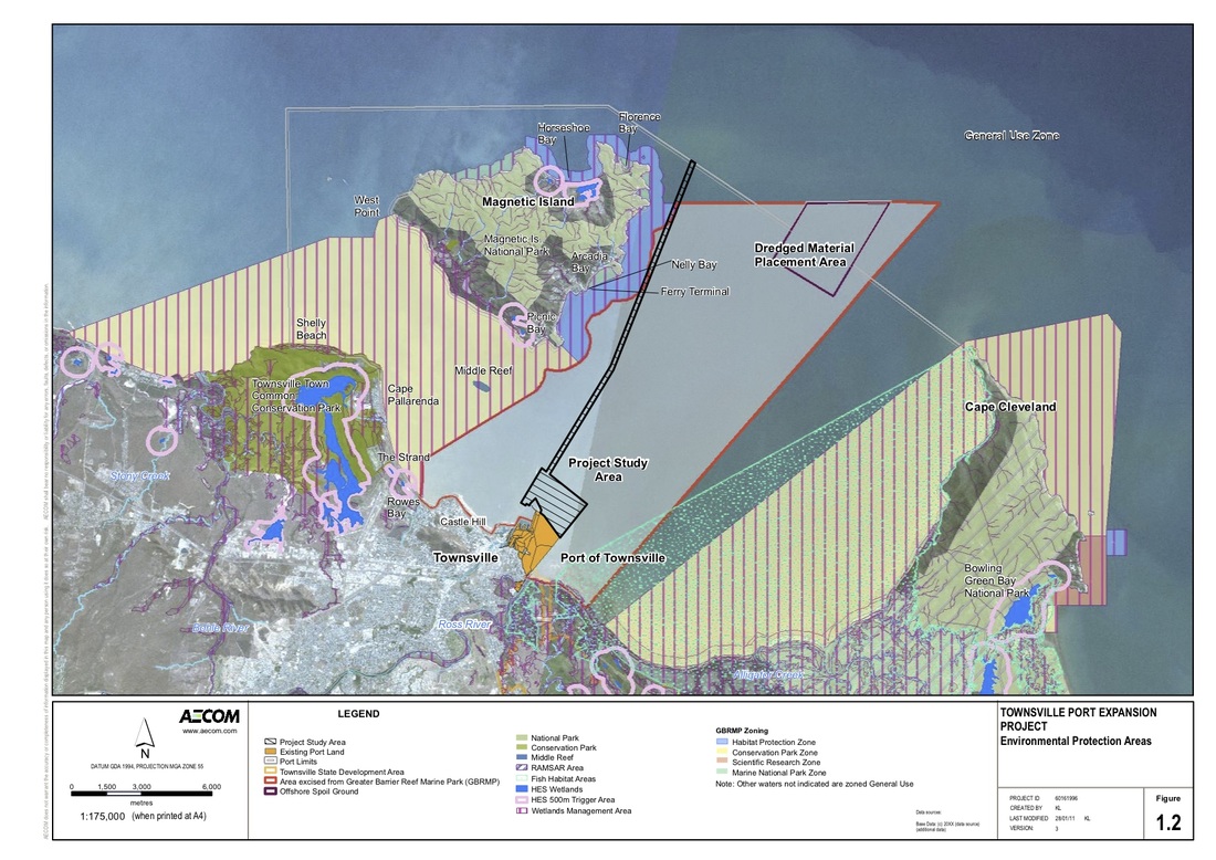 The Coastal Management Plan The Coastal Management Plan recognizes that coastal landforms and habitat can be protected by retaining the land in a relatively natural state and free from permanent or non-expendable buildings or infrastructure. Active management of coastal land is required to avoid loss or damage of vegetation and habitat; ensure surface flow modifications do not occur or, where necessary, do not cause erosion or create land instability; address adverse impacts caused by pest plants and animal; avoid intensive recreational activities impacting on ecological values or natural coastal landforms; control beach access, particularly by vehicles, to avoid erosion, protect ecological values, and ensure beach goers can enjoy the environment in safety. The management policy applies to coastal land and its resources within the coastal zone. Coastal land includes land under tidal waters, erosion prone areas, and at risk from storm tide inundation or permanent inundation due to sea level rise (collectively called coastal hazard areas), coastal roads and esplanades, reserves and unallocated State land, and other parcels of land adjacent to the foreshore. Coastal resources are the natural and physical features, processes, places or objects of the coastal zone that have ecological, economic or social value. This includes areas of high ecological significance (HES). Most of Magnetic Island is shown in the Plan as HES. The management policy applies to management planning, activities, decisions and works that are not assessable development under the Sustainable Planning Act 2009 and therefore not subject to the State Planning Policy for Coastal Protection (SPP). The proposed expansion of the Port of Townsville The main components of the proposed development include:
Click image to enlarge 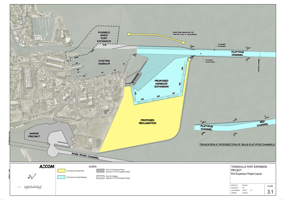 At this stage, comments are limited to those relating to the scope and presentation of studies and information required in the (EIS) Environment Impact Statement to allow for an assessment and decision on the appropriateness of the proposal, rather than the merits of the proposed action. MINCA will be making a submission on the proposed port expansion and invites others to collaborate in this submission. The deadline for submissions is 5pm Friday 2 March.
0 Comments
Your comment will be posted after it is approved.
Leave a Reply. |
Archives
November 2015
Categories |
- Home
- Our World Heritage Island
- About
- Donations
-
Environmental Resource Centre
- Ecosystems of Magnetic Island
- Geology of Magnetic Island
- Birds of Magnetic Island
- Butterflies of Magnetic Island
- Frogs & Toads (Amphibians) of Magnetic Island
- Feral Animals
- Life in the ocean around Magnetic Island
- Mammals of Magnetic Island
- Plants of Magnetic Island
- Weeds of Magnetic Island
- Reptiles of Magnetic Island
- Spiders, Insects & Bugs of Magnetic Island
- Library & Links
- Visitors' Guide
-
Projects
- Bolger Bay Conservation Park
- Caring for the West Point Road
- Protection of Radical Bay
- Townsville Port expansion >
-
Clear Water Townsville
>
- The Future of Cleveland Bay >
- The Story So Far
- Cleveland Bay: Current & Impacts
- The Impact of Dredging
- Dolphins, Dugongs & Turtles
- Where Have All the Fish Gone?
- Proposed Port Expansion & Master Plan
- Port of Townsville's Changing Plans
- How Many New Berths?
- Big Enough Already!
- Jobs and the Port
- The $1.64 Billion Quesion: WHY?
- Contact Clear Water Townsville
- Freecycle
- Achievements
- Gallery
- Contact
- Activities
 RSS Feed
WORLD HERITAGE MAGNETIC ISLAND - Worth caring for!
Magnetic Island Nature Care Association Incorporated (MINCA)
ABN: 74 879 004 873
PO Box 30, Magnetic Island Qld 4819
ABN: 74 879 004 873
PO Box 30, Magnetic Island Qld 4819
Privacy: MINCA will not disclose your email details to any organisation or individual without your prior written consent.
© 2020 Magnetic Island Nature Care Association
Website design by Butterfly House Web & Graphic Design
© 2020 Magnetic Island Nature Care Association
Website design by Butterfly House Web & Graphic Design